Drone flight planning and control software enables drone pilots to plan and execute their flights. These programs can be used for both amateur and professional drone pilots. The software makes the process of drone flight management easy and provides many benefits. It can be downloaded free of charge and comes with numerous features.
eMotion
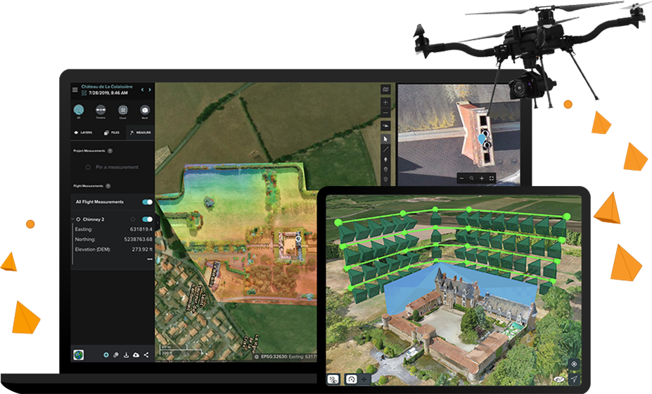
eMotion drone flight planning and controller software provides a comprehensive set of tools for flight planning, flight management, and ground station data collection. Its new version 3.5 includes a host of new features and functionality that make working life easier and improve workflows. These new features include the ability to use multiple languages for easier data collection, and automatic georeferencing of imagery for improved data quality. The software is also capable of integrating with industry-standard cloud solutions and live weather updates, so you can stay informed of conditions and trends.
eMotion drone flight planning and controller software allows users to adjust camera settings, including the picture format, white balance, exposure bias, ISO, and time target. The software can also help you measure distances, elevation changes, and other data relevant to your mission. Its software also enables you to review and reprogramme mid-flight flight plans and monitor battery levels.
eMotion also displays important drone data, including battery autonomy and wind speed. This allows you to concentrate on the safety of your flight and send quick commands in case of emergency. The software can also help you navigate faster, map more accurately, and save more time. And if you’re planning a multi-flight mapping mission, eMotion can automatically resume the mission at its exact location, so you can minimize duplication of flight lines and image captures.
The eMotion flight planning and control software is easy to use and intuitive. Its Simulator mode allows users to preview their drone flight plans as they are flying, and lets them customize their flights according to their preferences. Users can also import elevation data to make the flight plan more precise and safe. In addition, eMotion’s flight planning and control software has a confidence-building simulation mode that allows users to test flight parameters in windy conditions.
DJI FlightHub
The DJI FlightHub drone flight planning and management software enables companies to optimize workflow, manage drone fleets and assign tasks to pilots. It also offers real-time map views of remote operations. Additionally, the software supports up to four drones and automatically syncs flight logs for further analysis. Moreover, it can also be used with DJI Pilot, an app for controlling DJI drones.
The DJI FlightHub drone flight planning and management software is cloud-based and includes tools for project management, flight data streaming, and team collaboration. It is also user-friendly and accessible from any device with a web browser. FlightHub also has project management tools, which let you organize your missions based on specific project needs.
The DJI FlightHub software also provides a comprehensive overview of aircraft status, battery life, and more. It has an intuitive interface that enables you to organise work teams based on various criteria. Moreover, it offers features that allow off-site teams to monitor operations remotely. Another feature is the live streaming of video from up to four drones.
The DJI FlightHub drone flight planning and management software is cloud-based and provides full real-time situational awareness and control over drone fleets. The application also combines satellite maps and elevation data to offer 360-degree panoramas. This feature is especially useful for mapping operations and is designed to facilitate collaboration between ground teams and drone operators.
FlightHub supports most enterprise-grade DJI drones, including the Mavic Pro and Phantom 4 series. Moreover, it supports a wide range of capabilities, including infrared imaging, high-definition video, high-resolution stills, data gathering for crop analysis, and surveyor-grade mapping. The software is compatible with the DJI Pilot mobile app.
UgCS
UgCS drone flight planning and control software is a powerful tool for professional drone operators. Its wide range of features and tools helps streamline land surveying processes. It supports a variety of UAV platforms, including DJI M300 and M600 RTK, Ardupilot, and PX4-based platforms.
The program has a simple interface and multi-drone support. This means that one operator can operate a fleet of drones at the same time, while several computers can be connected to a main ground station for centralized control. It also allows you to plan missions at a specific altitude to improve the quality of 3D models. In addition, UgCS is capable of controlling drones equipped with LIDAR.
UgCS allows you to download 3D terrain elevation data. With this, you can plan missions at altitudes above sea level. You can also view real-time aerial video and mark points of interest on the map. With the software, you can even send your drone on automatic mapping missions.
UgCS allows you to set flight boundaries based on distance from your starting waypoint. Setting these boundaries will prevent your drone from flying too far or too high or violating local laws. By default, UgCS OPEN has boundaries of 500 m from your first waypoint and 120 m above ground level. However, you can modify these settings in the UgCS PRO version.
UgCS supports KMZ and.KMZ files, making them compatible with the drone. In addition, it offers several other features that make it a powerful tool for drone pilots. One of these features is the ability to import a waypoint from a KMZ file. The program also supports the ability to save a route in GeoTif (.tif) format and synchronize between a PC and a laptop.
Hammer Missions
The Hammer Missions feature in the drone flight planning and control software enables you to generate up-to-date 3D models of areas. It works by generating a double-grid flight path inside a shape that you draw. Then, you fly the drone along this path. The images you capture from this flight will overlap in the correct way, maintaining the correct image overlap between the two pictures. After the mapping mission is complete, you can pause it and resume the process.
The Hammer Missions feature is one of the most important parts of the drone flight planning and control software, and it allows you to capture high-quality data from the air. Its modular software architecture and artificial intelligence (AI) technologies make it easy to use and adapt to the needs of your specific mission. The software also features a number of features that ensure accurate flight planning and efficient data collection in the field.
Pix4D
Whether you are a professional drone pilot or simply an amateur, Pix4D drone flight planning and control (FPV) software can help you get the job done. The software allows you to create incredibly accurate maps and 3D models and even has a mobile app, so you can use it while you’re on the go. The software is also free and offers a 15-day trial.
Pix4D’s enterprise solution uses cutting-edge technologies to create enterprise-scale integration and support. It even comes with a service level agreement, enterprise training, and a customer support service. The Pix4D software platform helps you create accurate 2D and 3D models using advanced AI algorithms, and it even works with Anafi drones.
Pix4D drone flight planning and control programs are easy to use and can help you plan and execute a drone flight. Pix4D’s photogrammetry software can be used for medium to large-scale mapping, which can increase productivity and allow you to complete more projects with the same internal resources. It also helps you improve the accuracy of your data by allowing you to add ground control points and assess the accuracy of your results.
The software includes numerous options for drone flight planning and control, from importing geo-awareness maps to sending and receiving commands. Users can import geo-awareness maps and create custom flight plans for their drones, and they can also see restricted and no-fly zones. They can even customize notifications via audio and color-coded images.
The Pix4D drone flight planning and control program is designed to make it easy to fly a wide variety of drones. It can even handle multi-flight missions, allowing users to fly as many as four drones at one time. Moreover, Pix4D has programmable flight routines for a variety of popular drones.